3-D Wind Mapping for Drones
3D wind mapping provides detailed insights into wind behavior across your site, helping optimize designs for safety and efficiency. Whether for planning drone flight paths or enhancing outdoor environments, our analysis ensures your project is equipped to handle the complexities of wind with precision and reliability.
Our Service
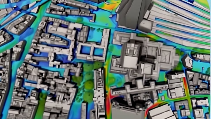
Wind plays a pivotal role in shaping the design, performance, and usability of landscapes, particularly in urban environments. By using 3D modeling to simulate wind effects, designers and engineers can better understand how wind interacts with various elements of a landscape, including buildings, vegetation, and open spaces. This process is especially valuable for optimizing drone flight paths, ensuring safe and efficient navigation through complex wind environments.
3D wind mapping allows for precise analysis of wind speed, direction, and turbulence across a project site. Simulations can incorporate data from sources like weather stations, GIS, or CFD models, enhancing the accuracy and depth of the analysis. The results—visualized through graphs, maps, or animations—help identify sheltered and exposed areas, assess microclimates, and optimize the placement of landscape features to improve comfort, reduce energy use, and support ecological functions.
For drones, this data is crucial in planning safe flight paths, avoiding areas of high turbulence, and enhancing operational efficiency. With 3D wind mapping, both landscape architects and drone operators can create environments and systems that are not only functional but also responsive to the complexities of local wind patterns.